
Scattered across American deserts, plains, sometimes fields, sometimes in the middle of nowhere: giant arrows made from concrete. The mysterious arrow signs were kind of forgotten for some time, but recently explorers rekindled their for discovering more and more of the arrows all over the United States.
Horse express, railroad mail, and finally airmail
The vast distance between America’s Atlantic and Pacific coast was covered first by horse-mounted riders relaying the mail. The 1860 Pony Express was advertised to take only 10 days from coast to coast. This time was decreased by railroad in late 1800s.
But introduction of airmail changed everything. Airplanes were much faster than railroad, but still relatively slow back in 1920s. Airco DH.4 was a typical airmail machine, and its maximum speed was 143 mph (230 km/h). Airplanes could travel only in daylight. These were times long before GPS and satellite navigation. It was only 20 years after Wright Brothers’ maiden flight, but aircraft were already commonly used for mail delivery.
Concrete arrows are constructed
The arrows were constructed as Transcontinental Airway System between 1923 and 1934. Funded in 1923 by U.S. Congress, they connected the Atlantic and Pacific coasts in 1924, and in 1933 the system reached a total 1500 beacons, and 18,000 miles of routes. This helped to decrease mail delivery time from coast to coast to only 3 days. Enthusiastic journalist back in December 1923 wrote an article about “Lighted Airway over Atlantic” (Popular Mechanics).
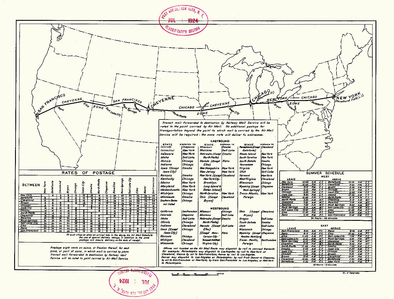
Each beacon consisted of giant concrete arrow 50-70 feet long pointing to the next beacon, and the 50-foot beacon tower with rotating light mounted at its top. The concrete arrows were painted bright yellow, and were illuminated by the tower light. Additionally, in the first year of operation 89 emergency airfields were established. Some beacons featured more than one arrow. The beacon stations were built 10-25 miles apart, depending on terrain situation. They were far apart on plains, and denser in mountainous terrain.
In the 1930s radio technology had improved, navigational aids were introduced, and low-frequency radio range was developed. Visual navigation by landmarks and concrete arrows was not a necessity anymore. With prices rising during Great Depression, the system was defunded, and after working in limited capacity for some years, finally rendered obsolete, and closed down.
Concrete arrow airmail beacons today
Many towers have been dismantled since 1940s. Some of concrete arrows were demolished in 1940s on purpose in case of enemy invasion, to hinder enemy aircraft visually navigating across the United States. Some of the arrows were consumed by new development, or just overgrown by grass. Only a few were developed into local landmarks by communities, but their popularity gains traction with explorers, travelers and wanderers. And hopefully, they won’t be forgotten.
Example of beacons as seen in Google Maps satellite view (2020)
You can find a detailed map of beacons here. Only places marked in red feature beacons that can still be found today.
Fact sources:
- Piloting the U.S. Air Mail: Flying for Uncle Sam by Lewis Edwin Theiss (1927)
- The American Aviation Experience: A History by Tim Brady (2000)
- The Journal of Air Traffic Control Association
Top image: Airmail navigation concrete arrow in St. George, Utah (Photo by Dppowell / Wikimedia Commons / CC-BY-SA)
Permalink
I have visited the arrow in Bloomington UT. Awesome place!
Permalink
dad took us on a nevada tour of concrete arrows back in early 2000s. they werent easy to find, no google maps back then 🙂